
Open access geoscience data: First global scale submarine landform dataset driven by terrain knowledge at 15 arc second.
Paper, code and dataset published by Yu et al (2025).
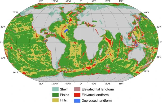
This dataset is reported to be “the first global scale submarine landform dataset at 15 arc second, which offers a new perspective on submarine landforms, providing key insights into seafloor geology, morphology, and dynamic processes.”
Abstract
“Submarine landforms are a critical component of Earth’s geomorphology, essential for understanding marine geological evolution, ocean dynamics, and marine ecosystems. However, global-scale classification of submarine landforms has been constrained by the lack of high-resolution data and insufficient integration of terrain knowledge. In response to these challenges, we propose a terrain knowledge-based submarine landform framework, which considers morphological features, spatial relations and undulating characteristics. Utilizing the General Bathymetric Chart of the Oceans at 15 arc second, a dataset of global submarine landform (GSL) is produced. The dataset includes the submarine landforms with 6 landform zones and 21 landform types, which reveals the diversity and complexity of submarine landforms. The comparison with existing 30 arc second global seafloor feature maps reveals that our dataset can reflect more detailed regional characteristics of the seafloor geomorphology. This dataset is the first global scale submarine landform dataset at 15 arc second, which offers a new perspective on submarine landforms, providing key insights into seafloor geology, morphology, and dynamic processes.”

Leave a comment