
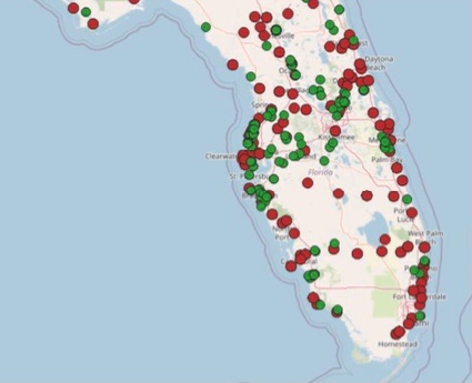
I came across this fascinating open access research paper by Lai et al (2022). Using NLP to extract street flooding events (green) and risk reduction projects (red) from hundreds of thousands of newspaper articles in the United States.
By spatially viewing this data gaps in governmental strategies could be identified.
I found this passage of particular interest. “Despite the financial, economical, and humanitarian impacts of flooding, nation-wide data on historic weather and climate data is typically limited to government sources such as the National Oceanic and Atmospheric Administration (NOAA), the United States Geological Survey (USGS), and the Federal Emergency Management Agency (FEMA), or held commercially by private companies. Even so, data collected by both gov- ernment and commercial databases have issues. On one hand, government sources often cover a wider geographical location than at the parcel level, many river and coastal areas have yet to be mapped (ASFPM, 2020), and even areas that are mapped have limitations and underestimate risk for populations (Technical Mapping Advisory Council, 2015). ”
You can read the paper here:
https://www.sciencedirect.com/science/article/abs/pii/S030645732100217X

Leave a comment